National Park Maps(npmaps.com)
npmaps.com
National Park Maps
http://npmaps.com/
60 comments
The site http://caltopo.com/ is another good resource for maps. The site includes a number of maps including USGS, USFS and marine charts. There are several useful overlays for hikers including trails and fire history.
I'm a huge fan of a little app called Maplets.[1] Has saved me on a number of occasions, and highlights how limited the big name mapping tools really still are for all kinds of navigation information.
[1]: http://www.mobilemaplets.com/
[1]: http://www.mobilemaplets.com/
Mee too, off to europe and maplets is my goto offline. https://www.openstreetmap.org/ and GPS on https://www.google.com/maps are supplements. What always surprises me is GPS working sans wifi and cellular
Thank you for mentioning this app. Purchased!
I love caltopo. I use it for all of my backcountry adventures. It also has historical maps in its database which make for a good time finding ghost towns and possible ruins.
Fro topo I use these maps too http://www.arcgis.com/home/webmap/viewer.html?useExisting=1
This is a great resource for someone to get started preparing a trip but when you're ready for topo detail, I highly recommend: https://mappingsupport.com/p/gmap4.php
It offers 8 different collections of topographical maps, some that include trails
It offers 8 different collections of topographical maps, some that include trails
Similarly, I took a weekend last summer and built www.mapofnationalparks.com to show on one map where all the parks were, and link to the official site / hiking, etc (with pretty pictures, of course).
Nice! As someone who loves to hike, you should add the National Forest Maps too: https://www.fs.fed.us/visit/maps/
Hi, I'm not the OP but I am the creator of NPMaps (many thanks to hownottowrite for submitting this). I would indeed like to get around to Forest Service maps after I finish with the national park units. However, they're lower on my to-do list because I've found Forest Service maps to be much more time-consuming to aggregate. Fewer people are searching for them as well.
So, it will happen eventually! I just can't promise it'll happen until I finish the national parks -- unfortunately, it'll be a while since I work a full-time job and this is just a side project when I have free time.
So, it will happen eventually! I just can't promise it'll happen until I finish the national parks -- unfortunately, it'll be a while since I work a full-time job and this is just a side project when I have free time.
I bet if you throw together a quick sign-up form and post it here soon you could get dozens of volunteers who would be willing to find the maps for a couple of places that you assign them and email them to you.
[deleted]
Yes, among other things there are a lot more NFs than NPs! Keep up the good work regardless - this is a public service you're doing. Hey maybe we should all crowdfund you to work full-time on the site for a year!
As the website states:
> NPMaps.com is an independent website and is not affiliated with the National Park Service.
> This is just a one-man project that gets worked on whenever said guy actually has some free time. It's hard work!
This is particularly important as NPS actually has an official Mapbox based initiative underway, here:
https://www.nps.gov/npmap/
https://github.com/nationalparkservice
In an attempt to unite their various datasets from around the country into one large system.
> NPMaps.com is an independent website and is not affiliated with the National Park Service.
> This is just a one-man project that gets worked on whenever said guy actually has some free time. It's hard work!
This is particularly important as NPS actually has an official Mapbox based initiative underway, here:
https://www.nps.gov/npmap/
https://github.com/nationalparkservice
In an attempt to unite their various datasets from around the country into one large system.
If you're into the aesthetic of these maps, http://www.reliefshading.com/ is a very nice resource explaining the process.
I usually hate pages that try to monetize via related affiliate links but this looks so genuinely useful and transports such a positive, down-to-earth and user-friendly vibe that I just love it. Well done!
Why?
I can understand review-spam kind of blogs where people just write a shitty review filled with affiliate links but there are tonnes of pages that do a good job at creating content and try to monetize a bit via affiliate links.
People hate ads, people hate tracking, hardly anyone pays subscriptions fees, and now if you hate even affiliate links, it comes across more as hating the fact that people are trying to make money from the content they have spent hours creating.
I can understand review-spam kind of blogs where people just write a shitty review filled with affiliate links but there are tonnes of pages that do a good job at creating content and try to monetize a bit via affiliate links.
People hate ads, people hate tracking, hardly anyone pays subscriptions fees, and now if you hate even affiliate links, it comes across more as hating the fact that people are trying to make money from the content they have spent hours creating.
Kind of correct. Probably it's only because I still remember the old "non-monetized" internet, but I just don't get the line of thought that posting some stuff on the web means everybody owes you a living. Lest we forget, those who want to make money from the internet are the more recent arrivals, and (especially at the time when it happened and I was young & idealistic) I found them to be like the crass uninvited guests who show up late and ruin the party (while thinking they actually turned a lame party awesome). Before they arrived, "the party" was full of useful sites like this, run by people for the simple love of whatever-it-was. The amateur internet, I suppose you'd call it. The reason this is a breath of fresh air is because it simply is what it is (not in the trying-to-assuage-my-disappointment sense, but in the no-deceptive-obfuscation sense) and in that way hearkens back to that era and doesn't bear the stench of today's typical swindles, schemes, and dubious offers. Yet it takes advantage of some of today's design tools/ideas and is a better quality experience than a lot of sites "back in the day."
Mind you, I don't begrudge anyone what they're doing, even if it's commercial, but the time you spent creating "content" may be worth something to someone, or maybe not. When you demand compensation, the bar is higher.
Mind you, I don't begrudge anyone what they're doing, even if it's commercial, but the time you spent creating "content" may be worth something to someone, or maybe not. When you demand compensation, the bar is higher.
>> "that posting some stuff on the web means everybody owes you a living."
You don't owe them a living, but specifically acting to rob them of a living that they are trying to earn without getting in your way (affiliate links or non intrusive ads or such) moves from idealistic to dickish.
New inventions or changes give rise to new paradigms, and with new paradigms come new ways to earn money or in general exchange goods and services.
You don't owe them a living, but specifically acting to rob them of a living that they are trying to earn without getting in your way (affiliate links or non intrusive ads or such) moves from idealistic to dickish.
New inventions or changes give rise to new paradigms, and with new paradigms come new ways to earn money or in general exchange goods and services.
Nobody said a thing about acting to rob anybody of anything. If you're trying to reopen the ad-blocking debate, I'm not really interested in that. I'm saying and I believe the grandparent is saying, sites with those features are to varying degrees less-good, precisely because of those features. Since I'm under no obligation to funnel myself into that site, I'll tend to ignore it, and I'm more likely to ignore it the less value it actually offers. (And the net value it offers, does decrease because of ads and adtech tactics.)
In my case I'm also saying, commerce itself is basically boring; I can find it anywhere.
I believe your use of the word "rob" is inappropriate since you can't be robbed of something you don't own. (My attention, the content of my web browser, etc.)
In my case I'm also saying, commerce itself is basically boring; I can find it anywhere.
I believe your use of the word "rob" is inappropriate since you can't be robbed of something you don't own. (My attention, the content of my web browser, etc.)
I am reminded of the time a poster here on HN threadcrapped [0] simply to post a non-affiliate link to an item mentioned in an article. His stated belief was that the article itself (or its author) was not worthy of an affiliate commission but the item mentioned in the article itself was of legitimate interest, and so he went out of his way to make sure readers could investigate the item mentioned in the article without giving affiliate credit.
All I can figure regarding the poster's true motivations in that thread is that there is some small percentage of the population that still gets syphilis, and some much smaller percentage that lets it go untreated, and some small percentage of the people in the tertiary stage of syphilis must post on HN...
[0]https://news.ycombinator.com/item?id=13285587
All I can figure regarding the poster's true motivations in that thread is that there is some small percentage of the population that still gets syphilis, and some much smaller percentage that lets it go untreated, and some small percentage of the people in the tertiary stage of syphilis must post on HN...
[0]https://news.ycombinator.com/item?id=13285587
I should have said something along those lines rather. Affiliate links are quite nice IF they are just a late addition and not the whole purpose of a site. This site seems genuine!
Thanks for the feedback! I've struggled quite a bit with figuring out how to best earn some income to cover my hosting fees (and ideally earn something more for all the work I've put into it). I experimented with Adsense but felt the ads were too intrusive and slowed down my page loading speed, and I didn't want to hurt the user experience. So I took a crack at creating some merchandise and using affiliate links, hoping that they integrate seamlessly and don't feel tacked on. I'm open to your alternative suggestions, however, if you think it feels like overkill (though I'm pretty dead-set against any donation buttons).
I appreciate your kind words as well! And thanks to OP for submitting my site.
I appreciate your kind words as well! And thanks to OP for submitting my site.
What user-friendly alternative do you propose to affiliate links? I'd rather have a link that I choose to click than ads and third party analytics loaded. On my handful of pages donate buttons don't convert. Affiliate links are the best way I've found to cover hosting costs while respecting my visitors bandwidth and privacy.
I did not mean it like that. Most pages where I see affiliate links only exist to serve those. This one seems like a genuine website created for good, not to make money.
Thank you for all the effort you've put into this project. Love the clean design and how you've used affiliate links and merchandising to monetize the site. A+ work.
Love the site! Great work. I wish pages like http://npmaps.com/colorado/ had big thumbnails/previews — would make picking a map easier than solely with text descriptions (which are well-written btw).
Thanks for the feedback! Admittedly, I'm pretty new when it comes to web design and have been sort of making it up as I go along. I ended up with the current layout because it was easy enough to code that I could figure out how to do it. I'm sure I could find some tools to allow hover image previews though - I'll add that to my (very long!) to-do list.
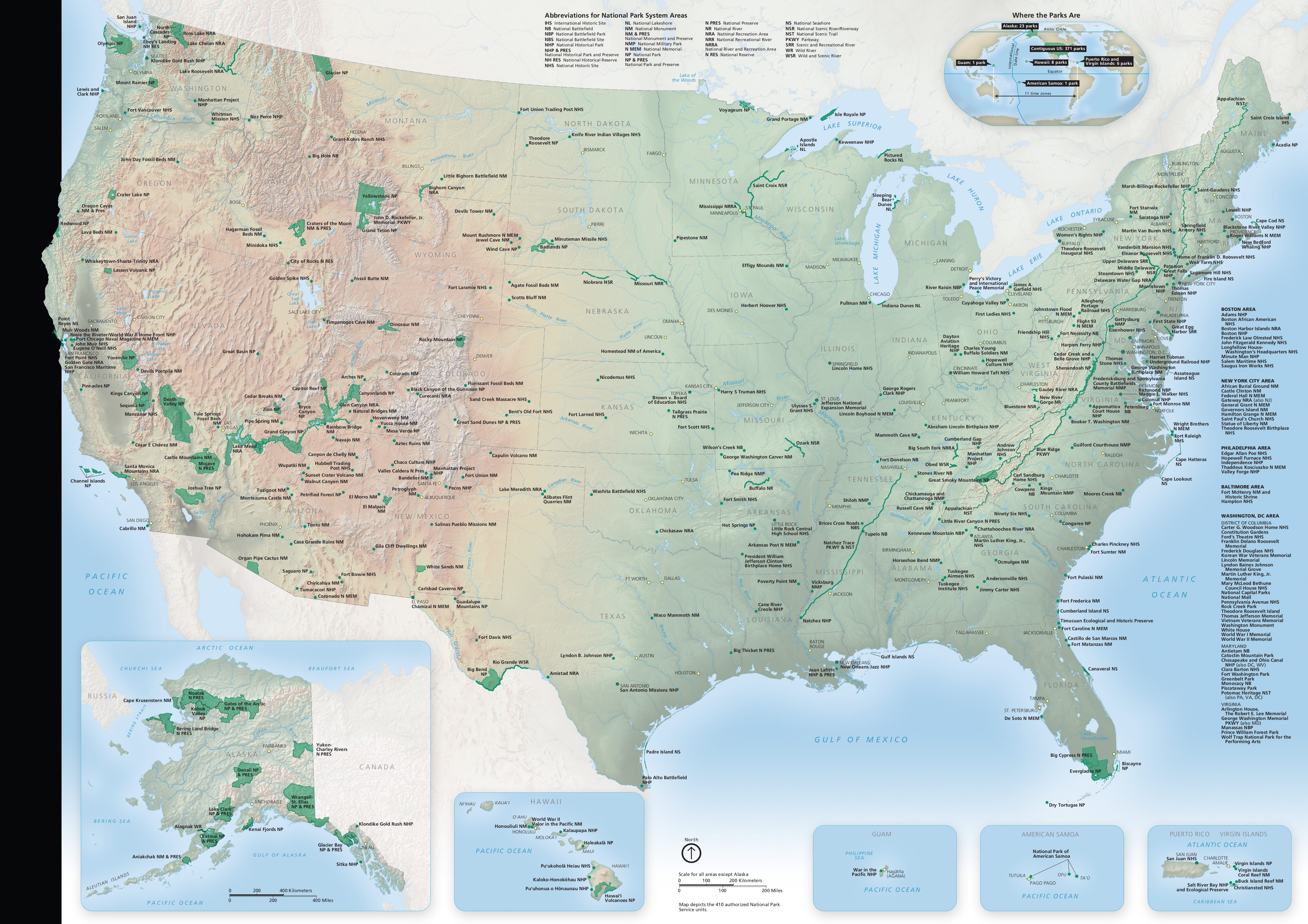
The south-west (including California) has a crazy amount of NPs http://npmaps.com/wp-content/uploads/national-park-map.jpg
What's the licencing situation on the higher res PDF maps? It might be cool to chop them up into tiles and use something like Leaflet [1] to display it in browser.
1: http://leafletjs.com/
1: http://leafletjs.com/
Speaking of maps, is there a good app with offline maps to use with your GPS?
I contribute to openstreetmaps when I visit an area and find the trails are missing. http://maps.me is available on mobil platforms and you can download map data by region for offline use. works very well in the backcountry with no cell service.
I know this isn't directly an answer, but I live in Utah and find that mapping on a device is not reliable in some of the parks, and definitely not out in the wilderness. The cell network just isn't 100%, and unless your device has a satellite-based GPS, your mapping won't work anyway.
I do agree that better apps are needed. I'm an avid explorer of Utah's western desert, and even with both paper maps and electronic, and prepping by looking at what Google maps thinks is correct and reviewing satellite imagery before I go, the patchwork of old abandoned dirt roads out there is still a maze much of the time.
The point being... when going out into the wilderness, even with a good app, please don't rely on it 100%. Plan well and be safe.
I do agree that better apps are needed. I'm an avid explorer of Utah's western desert, and even with both paper maps and electronic, and prepping by looking at what Google maps thinks is correct and reviewing satellite imagery before I go, the patchwork of old abandoned dirt roads out there is still a maze much of the time.
The point being... when going out into the wilderness, even with a good app, please don't rely on it 100%. Plan well and be safe.
Maybe check https://www.blm.gov/maps/georeferenced-PDFs for coverage.
I expect the BLM maps would be at least as detailed as Google and probably better.
I expect the BLM maps would be at least as detailed as Google and probably better.
Yes, IF you have an actual GPS device. My point is that most people's mapping on their cell phone is running off the cell network, not the actual GPS network, so will fail once you lose signal. Including mine. :)
I primarily use paper maps and a compass, to be honest. It might be old-school, but it still works if my batteries die.
EDIT: OK, I stand corrected! I just am the old guy who hasn't updated my phone in forever. My iphone 4 doesn't cut it apparently... But my paper and compass really does work.
I primarily use paper maps and a compass, to be honest. It might be old-school, but it still works if my batteries die.
EDIT: OK, I stand corrected! I just am the old guy who hasn't updated my phone in forever. My iphone 4 doesn't cut it apparently... But my paper and compass really does work.
Smart phones generally have a dedicated GPS receiver (with support for several satellite constellations). A smart phone dependent on the network for positioning would be an exception at this point (they certainly use the network to speed up location acquisition and improve precision, but they are not dependent on it).
But what can happen while traveling into new areas is that whej data link drops the mapping ap blanks, rendering the gps fix less than useful and giving the impression that the device is dependant on data coverage. Most phones have a facility to pre-download maps to cover this situation but you need to know to do it.
GPS receivers without maps are still perfectly useful if you have appropriate paper maps. And even if you have a dedicated GPS receiver with maps you need to pre-download maps as well.
By all means have paper maps and a compass as a backup but I doubt there's a smartphone on the planet today that doesn't have a built-in receiver for GPS satellites. They may (probably do) also use WiFi and cell signals to speed GPS reception but they're in no way dependent on those other signals for GPS tracking unless they can't pick up a GPS signal indoors etc.
Can be worth getting a second-hand GPS watch as another option. Lightweight, useful and you are probably already carrying a powerbrick to charge your phone anyway so that covers recharging overnight.
Um, what? A satellite-based GPS? As opposed to a GPS that doesn't use satellites? All GPSes are satellite-based.
Google Maps plus some satellite images is usually pretty good, and of course nothing beats being prepared. (Bring MUCH more water and sun protection than you think you need!)
Google Maps plus some satellite images is usually pretty good, and of course nothing beats being prepared. (Bring MUCH more water and sun protection than you think you need!)
Google Maps is terrific on pavement. Get off pavement in the Rockies and no, it is about 80% accurate. Good enough to make you think it is going to lead you right... until it sends you completely wrong. Believe me, those of us who spend our weekend off-road in the West are painfully aware of exactly where Google's limitations lie.
I spend a decent amount of time exploring strange parts of the world, and in my experience with several different phones in several different countries is that GPS (assuming your phone is charged and you're not in a cave/underground) is always good enough to get you out of wherever you are.
To give some examples, in the past twelve months or so I've navigated by GPS (using Google Maps to visualize my position) in mountains in Iran, semi-rural Ukraine, forests in France, middle-of-nowhere Canada, and forests in America. In case you think that my GPS worked just because I had good devices, I've used everything from a nice iPhone 6+ to a decent Galaxy S5 to a crappy Huawei P8 Lite which I bought for $65 used.
I'm not sure how you can quantify GPS as "80% accurate". Does that mean 20% of the time it puts you in the next state over? Or that it's 200 meters off? I can't think of a reason why your GPS position would be wrong... it's not as if physics just breaks down in the Rockies.
In order to get such tremendously poor results, I have a feeling that you did something like turning off GPS (which forces your phone to rely on cell tower triangulation) or using GPS where it doesn't work (like in a cave.) If the actual, raw values from your GPS were wrong I would be extremely surprised.
To give some examples, in the past twelve months or so I've navigated by GPS (using Google Maps to visualize my position) in mountains in Iran, semi-rural Ukraine, forests in France, middle-of-nowhere Canada, and forests in America. In case you think that my GPS worked just because I had good devices, I've used everything from a nice iPhone 6+ to a decent Galaxy S5 to a crappy Huawei P8 Lite which I bought for $65 used.
I'm not sure how you can quantify GPS as "80% accurate". Does that mean 20% of the time it puts you in the next state over? Or that it's 200 meters off? I can't think of a reason why your GPS position would be wrong... it's not as if physics just breaks down in the Rockies.
In order to get such tremendously poor results, I have a feeling that you did something like turning off GPS (which forces your phone to rely on cell tower triangulation) or using GPS where it doesn't work (like in a cave.) If the actual, raw values from your GPS were wrong I would be extremely surprised.
The 80% accurate statement is about the maps themselves. Google maps will show a road that just doesn't exist. Or you will be driving down on a road that isn't on the map. Or the map will show the road going through, even though you are at its end, looking at a cliff. It will show intersections that do not exist.
In some cases, I can tell they used old data. I know one road in particular that did exist 30 years ago, but the forest service deliberately closed off when a rock quarry closed, and it has been re-forested. It still shows on the maps. Another that shows on the maps was planned to be built by the BLM, but never was... yet the map shows it. So I'm not sure exactly what data set they built their maps from, but clearly it did come from data, not actual exploration... because the dirt roads in the American west are just not accurate.
In some cases, I can tell they used old data. I know one road in particular that did exist 30 years ago, but the forest service deliberately closed off when a rock quarry closed, and it has been re-forested. It still shows on the maps. Another that shows on the maps was planned to be built by the BLM, but never was... yet the map shows it. So I'm not sure exactly what data set they built their maps from, but clearly it did come from data, not actual exploration... because the dirt roads in the American west are just not accurate.
In general, the information on maps about dirt roads in the US West can be hard to rely on. Some of the information, as you say, is just out of date.
But it's also the case that dirt roads range from well-maintained and graded to you'd better have a jeep and know how to drive it--and the distinction isn't always obvious on a map (digital or otherwise). Road conditions also vary based on season, weather, and how recently there's been maintenance work done.
Someone stated in an earlier discussion that part of the issue is that a lot of this dirt road data is from US Census TIGER data, which was never intended for automotive navigation. [1]
[1] https://news.ycombinator.com/item?id=11657931
But it's also the case that dirt roads range from well-maintained and graded to you'd better have a jeep and know how to drive it--and the distinction isn't always obvious on a map (digital or otherwise). Road conditions also vary based on season, weather, and how recently there's been maintenance work done.
Someone stated in an earlier discussion that part of the issue is that a lot of this dirt road data is from US Census TIGER data, which was never intended for automotive navigation. [1]
[1] https://news.ycombinator.com/item?id=11657931
The accuracy statement is about the maps.
Google Maps can be pretty spartan in wild parts of the US.
Google Maps can be pretty spartan in wild parts of the US.
I would suggest getting a "Benchmak Maps" atlas of the state you are traveling in. About $25 each. The whole state at 1:300,000 with comprehensive coverage of many features. You will find all the dirt roads and many trails. Good for driving into and around the back country. For hiking, especially off trail, I prefer good old 1:24,000 USGS maps.
I recently used Gaia GPS ($20ish on iOS) on a few Utah hikes. It was useful but I don't know that I'd want to be completely reliant on it. The cacheable maps it was using in The Maze district of Canyonlands, for example, were missing some trails and features. When the GPS was working (outside narrow canyons), I found the topography and accuracy quite good, but even basic routes were creative enough that you needed to know where the trail was or you wouldn't make it through.
Maplets is a really good iOS app for searching and using maps.
https://itunes.apple.com/us/app/maplets-the-offline-maps-app...
https://itunes.apple.com/us/app/maplets-the-offline-maps-app...
On iOS, I've used Pocket Earth for years and really like it. They added topographic maps awhile back, and also have integrations with Wikipedia/Wikivoyage. I have pins and stars of POIs from all my trips saved (and exported) through that app.
https://pocketearth.com/
https://pocketearth.com/
I use BackCountry Navigator on Android for hiking and four-wheeling.
https://play.google.com/store/apps/details?id=com.crittermap...
https://play.google.com/store/apps/details?id=com.crittermap...
http://osmand.net/ is excellent plus you can install it from https://f-droid.org/.
I don't know if the NPS pdfs are georeferenced, but Avenza Maps is a nice app for working with pdf maps on phones and tablets.
(It's relatively low hanging fruit to georeference the maps, but they may not update them frequently and so wouldn't have responded to the popularity of smart phones yet)
(It's relatively low hanging fruit to georeference the maps, but they may not update them frequently and so wouldn't have responded to the popularity of smart phones yet)
Avenzamaps has a marketplace, so you can find georeferenced maps from all sorts of providers. For US hiking and trail running they are without peer.
In Europe companies like outdooractive.com combine maps with data points like hotels and vendors.
In Europe companies like outdooractive.com combine maps with data points like hotels and vendors.
I've been using onXmaps Hunt. Their property and land data is pretty amazing, and have offline support. They have a lot of nice features geared towards hunters like tracking, drawing lines, shapes, but it is still useful for non-hunters like me.
As others have mentioned there are a range of OpenStreetMaps-based apps--I use maps.me on iOS--that have variously good or bad levels of trail detail. In the UK the digital versions of the Ordinance Survey maps are quite good in my (limited) experience.
As an avid hiker I've been using https://www.alltrails.com app which lets me download just a segment of a map that a trail is on and is detailed enough for me to follow.
Get a Garmin etrex and put OSM maps on it.
OSMand
There's a whole range of OpenStreetMap based apps and even programs that will process OpenStreetMap data into the custom formats used by various dedicated GPS units.